New radar system for snowpack analysis: first tests
A prototype radar system that instantly analyzes the composition of the snowpack during melting has recently been tested in terraXcube’s Large Cube. The system called “Snowave” was developed by the University of Pavia’s Microwave Laboratory and later improved and fine-tuned in part by the “CRIOSAR: SAR Applications to the Cryosphere” project funded by the Italian Space Agency with the involvement of the Eurac Research experts.
 © Eurac Research | Riccardo Parin
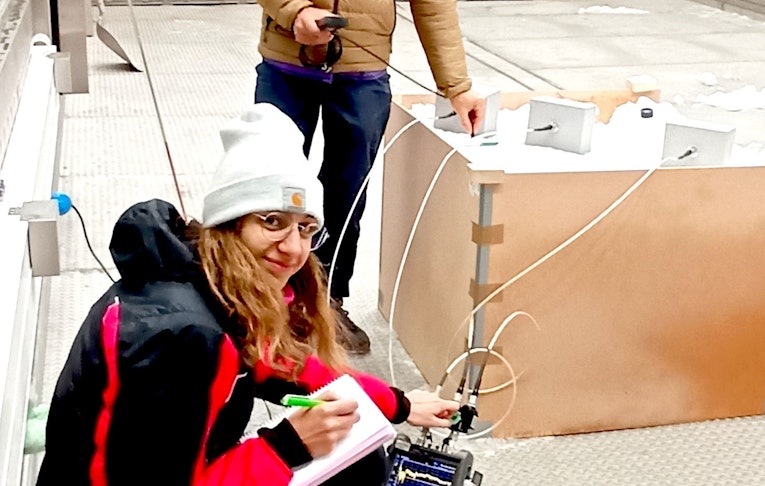
Analyzing and measuring how snow melts, typically in spring, is important to understand the state of the snowpack and the amount of water available for the immediate future. However, taking these measurements is particularly challenging because they have to be done manually. “One has to dig a trench in the snowpack and perform a series of measurements following a standard protocol. Usually we measure snow density, snowpack height, snow grain shape and type, and free water content: the water generated the moment the snowpack is melting.” explains Carlo Marin, a researcher at Eurac Research’s Institute for Earth Observation and one of the researchers who worked on the prototype.
Snowave is a radar instrument that uses waves of different types to instantly analyze the height, snowpack density and free water content without the need for any manual intervention. To do this, the dual receiver multifrequency device works using different radar echoes at the same time to estimate snow parameters and different types of antennas that work at different frequencies.
Before testing the technology under real conditions next spring, the researchers decided to put it to the test inside terraXcube. “In one day, we usually manage to make few measurements when we are out in the field. However, in terraXcube, we managed to make more than 100 measurements in just a few hours,” explains terraXcube engineer and test manager Riccardo Parin.
 © Eurac Research | Riccardo Parin
The test opened up the possibility of continuing to test this type of technology in a controlled environment before using it in the field. After the first round of testing, Snowave can now either be miniaturized and mounted on a drone. “The ultimate goal is to use the radar system repeatedly by flying a drone over the analysis area so as to have a temporal and spatial overview of the snowpack and understand in real time how it is evolving,” explains Carlo Marin.
In order to give you a better service this site uses technical cookies. Additionally third party cookies are used for embedded content. If you decline, you will not see content from third parties (such as Youtube videos or Facebook/Twitter content). Privacy policy